I have promised to describe my short journey from Białystok to Stegna at the seaside.
http://mapa.edu.pl/dojazd/bialystok_28752_stegna_8683.htm
It took about 5 hours, but was a little tiring. Half of it via Mazovia District
http://en.wikipedia.org/wiki/Mazovia
and Mazurian Lake District
famous for its wonderful lakes, but I was rather driving through small local roads in the forests, also passsing the city of Łomża (at Mazovia) and then small villages, where people were taking care of their cows and other animals, like in older times in books.
Also visiting KURPIOWSZCZYZNA in Mazovia, a small traditional region where local folk lives.
http://www.kurpiowszczyzna.info/content/view/85/45/
And then the town of NIDZICA, WHERE THE OLD GOTHIC CASTLE is a lovely attraction. Only the second part of the journey was easier when I reached the motorway from Warsaw, our capital to the sea. It was getting dark at that moment, and the sky had lovely red-orange-pink colours.
The next day early in the morning I went with my dear sister to see what we love forever- our sea.
Enjoy the journey.
Dziś wracam myślą do podroży, którą odbyłam z moją drogą siostrą z Białegostoku do Stegny, tydzień temu. 5 godzin, pierwsza połowa przez lokalne dróżki, wsie, pola i lasy, druga już drogą ekspresową, łatwiejsza.
Poprzez Mazowsze, Łomżę, całą w robotach drogowych, Mazury, Nidzicę z jej zamkiem z czasów Krzyżaków, wioseczki na Kurpiowszczyźnie, dopiero potem wyskakując wieczorem na trasę warszawską już na samo Pomorze w stronę Krynicy Morskiej, do Stegny.
Poniżej foty: krówki na Mazowszu lub już nawet Mazurach, Nidzica, zachód słońca na ekspresówce w kierunku morza i poranek w Stegnie, droga nad morze...i w końcu upragnione-morze.
Cows walking home somewhere at the border of Mazovia and Mazurian Lake District
Gothic castle in NIDZICA
Sunset on the motorway to Pomerania, closer and closer to the seaside
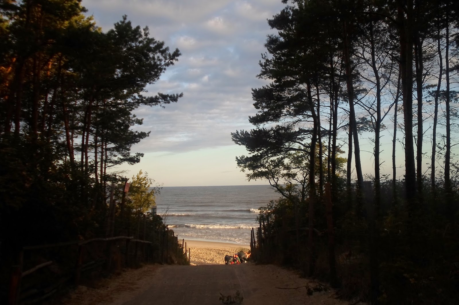
Early in the morning on the naxt day from this place in Stegna we start our stroll
Then the road in the forest, signposts to the different resorts
Nordic-walking ar 6.30 am is really...refreshing
There it is, the only goal, one and only
Isn't it beautiful???
I am back at work, summer stil is here but holiday is over.
So now I am not able to write posts every day.
Only as possible.
In last days of August I dreamed of visiting Tatra mountains, but it was not possible.
However, I was on a short journey to Białystok, a city that is on the eastern/northern end of Poland abot 70 km from Belerus.
For people like me, living around German and Chech border it is a very distant and different place, for example a lot of inhabitants belong to Orthodox Church.
But I was so lucky to visit BALTIC SEA, for one day I went to STEGNA, a small village not very far from KRYNICA MORSKA.
http://najlepszy-wypoczynek.pl/atrakcje-stegna,lp,470.html
http://www.metropoliagdansk.pl/kim-jestesmy/czlonkowie-gom/gmina-stegna/
https://www.google.pl/search?q=STEGNA+IN+ENGLISH&source=lnms&tbm=isch&sa=X&ei=K5YFVNb1FOaN7QbYl4G4Ag&ved=0CAYQ_AUoATgK&biw=1366&bih=660#facrc=_&imgdii=_&imgrc=oW3pQRPGw5SZfM%253A%3B3pJKCMAE_jurpM%3Bhttp%253A%252F%252Fupload.wikimedia.org%252Fwikipedia%252Fcommons%252F1%252F11%252FMap_-_PL_-_powiat_nowodworski_-_Stegna.PNG%3Bhttp%253A%252F%252Fpl.wikipedia.org%252Fwiki%252FStegna_(gmina)%3B1024%3B683
I will describe the trip more profoundly in next days, today some lovely pictures entitled:
FAREWELL SEA AND SUMMER...
Na pożegnanie lata udało mi się odwiedzić morze.
Byłam w Stegnie, niedaleko Krynicy Morskiej, czyli na samym północnym wschodzie Polski.Miałam okazję być z Białymstoku, który jest oddalony ok 70 km od granicy z Białorusią i od morza dzieli je około 5 godzin jazdy autem.
Gdyby była trochę lepsza droga może byłoby krócej.
To opiszę innym razem.Dziś foty z pożegnania lata.
ŻEGNAJ LATO, ŻEGNAJ MORZE.....
AT 7 AM GOING TO THE BEACH
NA ZAKOŃCZENIE LATA PIĘKNA STARA FRANCUSKA PIOSENKA
o morzu, z filmu "Wakacje Jasia Fasoli".
Dziś złapałam pierwszy katar, zimno i pada, Trzymajmy się miłych wspomnień.
LAST DAYS OF SUMMER, I got first cold, awful
Today I saw a funny film Mr Bean holiday and at the end thare was a lovely old French song La Mer (SEA).
http://www.youtube.com/watch?v=9m9dtB6CT50
AND THE OTHER VERSION
http://www.youtube.com/watch?v=fd_nopTFuZA
CANNES I WAS THERE
AND IN NICE......
THIS IS ME WITH MY FRIEND EWA THOUSANDS OF YEARS AGO IN NICEEEEE, FRANCE
ja i moja koleżanka Ewunia, wiele lat temu w Nicei na koniec lata
TODAY FOR THE REASON THAT IT IS MY BIRTHDAY, and also because I may be quite busy next days, I will make longer post,
that is more pictures will be included.
YESTERDAY
I was writing about NOSAL (mountain) and NOSALOWA PRZEŁĘCZ (pass), and I promised that next time I am going to mention DOLINA OLCZYSKA (VALLEY).
http://pl.wikipedia.org/wiki/Dolina_Olczyska
http://pl.wikipedia.org/wiki/Jaszczurówka
http://www.tatry.info.pl/wysokie/gasienicowa/kopieniec.php
https://www.facebook.com/media/set/?set=a.294464213969588.69649.108869922529019&type=1&comment_id=1787320&offset=0&total_comments=1
http://www.zakopane.pl/en/tourism/hiking-tours/jaszczurowka-chapel-olczyska-valley-kopieniec-time-to-walk-3-5-h
Z OKAZJI MOICH URODZIN DZIŚ WIĘCEJ ZDJĘĆ, DOLINA OLCZYSKA, KROK PO KROKU.
Powyżej linki polskie i angielskie.
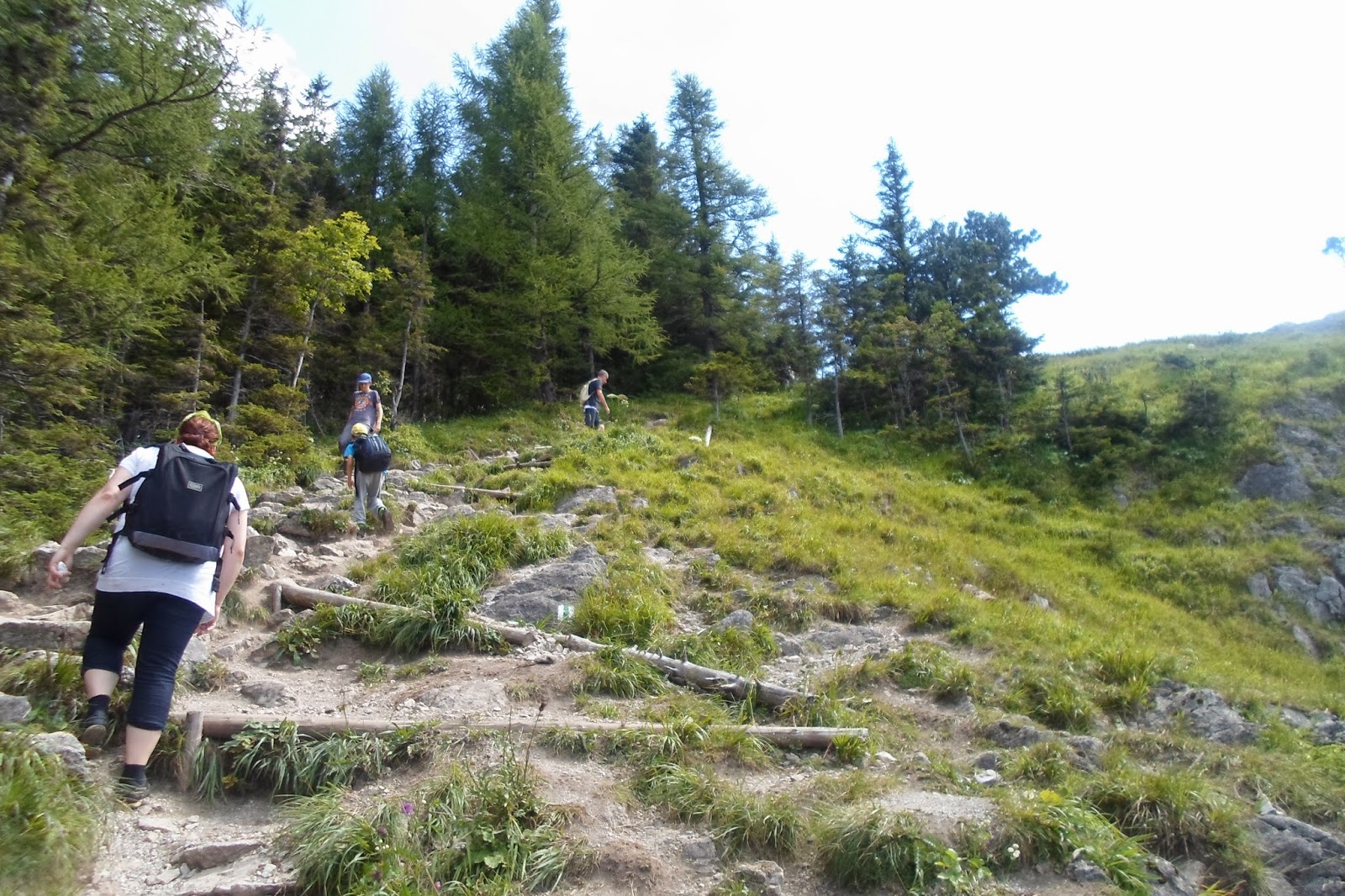
As I said previously, to NOSALOWA PRZEŁĘCZ YOU MAY GO FROM MUROWANICA AND NOSAL, OR FROM KUŹNICE,
THIS IS THE ENTRANCE TO NATIONAL PARK OF TATRA IN KUŹNICE .
WSTĘP DO NARODOWEGO PARKU W KUŹNICACH
THE ROUTE LEADS THROUGH THE FOREST
Początkowo przez las
AT NOSALOWA PRZEŁĘCZ (PASS) WHERE THE ROUTS MEET, WHEN YOU GO TO THE LEFT-THERE IS NOSAL (MOUNTAIN) (post from yesterday) ON THE RIGHT A WAY TO OLCZYSKA VALLEY,
Na Przełęczy Nosalowej mozna iść w lewo i dojśc do Nosala (łagodniejsza strona dojścia na tę górę-vide wpis z wczoraj) lub na prawo do Doliny Olczyskiej
WHEN YOU GO RIGHT YOU SEE FROM THE DISTANCE A MOUNTAIN KOPIENIEC (1328 M ASL)
Jeśli pójdziemy w prawo zobaczymy piękny widok Wielkiego Kopieńca z oddali (1328 m npm)
BUT FIRST YOU SEE THE OLCZYSKA VALLEY BELOW, VERY NICE PLACE
Ale najpierw widok Doliny Olczyskiej, niedużej, ale malowniczej
JUST IN HEAVEN - MEADOWS AT OLCZYSKA VALLEY
Pięęękne łąki na Olczyskiej
AND OLCZYSKA
I Olczyska
NOSAL is not vey high (1206 mnpm, above sea level -ASL),
usually we go there on the first or the last day, or when the weather is not that good as it should be.
Unfortunatelly, some people think that it is a walking-route so they go like for a stroll in not very comfortable shoes.
Not a good decision.
Our opinions will then be dependent on from which side we start.
The route starts
1. from known point in ZAKOPANE - that is KUŹNICE (the district of the town),
or
2. from the bus stop MUROWANICA.
From the 1st side I think it is much easier, cause hiking up from side of MUROWANICA may be a little harder.
OK, do not worry it is still not the high part of TATRY (TATRA MOUNTAINS).
When you find yourself on the side of KUŻNICE it is possible to make the trip longer and to go through NOSALOWA PRZEŁĘCZ (small mountain pass) further to DOLINA OLCZYSKA, very small but also nice valley.
About OLCZYSKA I will continue next time....
Have a good time watching pictures, especially that one with just-married-couple probably on the wedding session wit a photographer.
I have almost forgotten: from NOSAL there is a beautiful panorama of the mountains including our famous KASPROWY WIERCH.
A film
http://www.youtube.com/watch?v=vDNxRgiS22E
some links
http://natatry.pl/tatry-wysokie/regle-tatr-wysokich/na-nosal-z-kuznic
http://pl.wikipedia.org/wiki/Nosal_(Tatry)
NOSAL, TO KOLEJNE MIEJSCE GDZIE czasem można spotkać turystów w klapkach i sandałach. Jednak nie polecam bo zwłaszcza wejście od strony przystanku MUROWANICA jest momentami ostre, mimo, że przecież nie jest to wysoka górka.
Z drugiej strony szlaku można odbić na NOSALOWĄ PRZEŁĘCZ i udać się dalej do DOLINY OLCZYSKIEJ, ale o tym następnym razem.
Z NOSALA, jak wiadomo, piękne widoki...
Trafiła się nawet sesja ślubna.
od MUROWANICY, FROM THE SIDE OF MUROWANICA
AND HOW IT LOOKS IN WINTER ORAZ ZIMA NA NOSALU
http://bi.gazeta.pl/im/f3/0a/cd/z13437683Q,Zakopane---Nieczynny-wyciag-krzeselkowy-na-szczyt-.jpg
TODAY shortly.
When we plan to go to the mountains it is absolutely obligatory to check the weather.
This year it changes so quickly.
To feel safe before going for a longer trip or to higher parts of mountains the best thing we can do is to trace cameras live situated there.
And watch local wather forecasts, not those shown in news.
So I place now a link to live cameras.Enjoy
http://tatromaniak.pl/aktualnosci/c/robi-sie-pogoda-wieczor-z-kamerkami-na-zywo
http://kamery.topr.pl/kamery
Nie trzeba chyba mówić, kto był w górach to wie, że pogoda lubi się tam zmieniać szybko.
W tym roku chyba szczególnie.
Aby czuć się bezpiecznie, przed wyjściem w dłuższą podróż lub w wyższe partie górpo prostu musimy zainteresować się pogodą, najlepiej informacją TOPR.
Warto śledzić kamery internetowe.Powyżej linki.Miłego wieczoru i dnia i nocy.
Przysłop Miętusi, za plecami KOMINIARSKI WIERCH
PRZYSŁOP MIĘTUSI (SMALL MOUNTAIN PASS),
AND BEHIND ME A VIEW OF KOMINIARSKI WIERCH,
the mountain which we cannot visit - the route is closed there for unique species of eagles which live there.
KOMINIARSKI WIERCH
I would like to share my other pictures from the biggest and longest valley in TATRY mountains DOLINA CHOCHOŁOWSKA.
Because I have mentioned it before I give the link to the previous description, so they could be close "attached".
http://ultrasogood.blogspot.com/2014/08/dolina-chochoowska-tatry.html
Enjoy looking at the valley, at the end of it there is a mountain hostel (shelter) (on the picture me at the entrance) , which is not bad as comparing with other ones in the mountains.
During season you may eat there some delicious food like Polish pierogi (dumplings) filled with berries or pancaces with berries, yammi !!!
From that place you may also go further to see mountains GRZEŚ, RAKOŃ and WOŁOWIEC or as I was writing 2 days ago, to STAROBOCIAŃSKI WIERCH.
http://pl.wikipedia.org/wiki/Grze%C5%9B
http://forum.nikoniarze.pl/showthread.php?t=240241
Dziś ponownie Dolina Chochołowska, najdłuższa z wszystkich w Tatrach.
Na końcu bardzo miłe schronisko, w którym można zjeść coś bardzo pysznego z jagodami lub też z tamtych okolic wyruszyć dalej na
GRZESIA, WOŁOWCA
lub nawet na STAROBOCIAŃSKI WIERCH,
z którego po wielogodzinnej trasie można dojść do Hali Ornak w Dolinie Kościeliskiej.
DOLINA KOŚCIELISKA, some people say it is the most beautiful in our TATRY, some prefer CHOCHOŁOWSKA, by the way there is a route between 2 of them.
It has about 9 km and from there you may go to see magnificent caves that are open for tourists (JASKINIA MROZNA, cave) a film below.
http://www.youtube.com/watch?v=589BXLJy6NQ
Also a known WĄWÓZ KRAKÓW (GORGE KRAKOW).
http://tatromaniak.pl/aktualnosci/c/wawoz-krakow
It is not a secret that DOLINA KOŚCIELISKA is the most famous valley in TATRY.
In summer or during long weekends crowds are visiting it, it quite easy,
when me mean hiking, rather it is walking so families with children like it, as well.
Links abot the valley and my numerous pictures comparing KOSCIELISKA in summer and in winter at the beginning of March 2014.
http://pl.wikipedia.org/wiki/Dolina_Ko%C5%9Bcieliska
crowds in Kościeliska - typical during seson /// tłumy w Kościeliskiej
http://www.tatry.gory24.pl/foto/menu/dolina_koscieliska_zdjecie_glowne.jpg
https://blogger.googleusercontent.com/img/b/R29vZ2xl/AVvXsEgZ9L5rhLxzM809dU7tHpHDb2dPZinm0H-yr4I_Svub1EzzPYTdHtXkPzL66WhLYi_E1pdKxg-tU-2bKS-n8bJUZMbKeRtO9WcZ4-48LSpLz7uhPJZLuEvkq-t5pFyRwjbKB_vS9QwLZ5E/s1600/AG-1.jpg
http://www.tripadvisor.co.uk/Guide-g1087270-i2039-Koscielisko_Lesser_Poland_Province_Southern_Poland.html
http://tatromaniak.pl/szlaki/rejon-doliny-koscieliskiej/dolina-koscieliska
Nic dodać nic ująć, to najsłynniejsza nasza dolina, razem z Chochołowską, zresztą są połączone szlakami.
Ma około 9 km długości, można od strony doliny pójść zwiedzać znane jaskinie np. Mroźną lub Wąwóz Kraków.
Powyżej ciekawe linki polskie i angielskie, film, a potem zdjęcia do porównania KOŚCIELISKA W ZIMIE I W LECIE.Miłego dnia i nocy.
Sorry again my summer pictures are mainly with me.
i zima AND WINTER
MY MISTY MOUNTAINS
STAROBOCIAŃSKI WIERCH.
This is the name of the mountain in TATRY, I havn't been there yet, but really I would like to be. The route is quite long, however not that hard as in High Tatry.
Tatry are divided into eastern - (HIGH TATRY) and western part, the line is crossing PRZEŁĘCZ LILIOWE (mountain pass).
http://portaltatrzanski.com/images/przewodnik/foto/pl032-przelecz-liliowe/pl032%20-%20przecz%20liliowe%202.jpg
Below some links
1. about Starobociański Wierch,
2. the route
3. and a very nice page I have found about juorneys not only to Tatry, but to different places in Poland at the seaside, mountains, lakes and others-it is in Polish, but pictures are very nice, there are also maps etc.
1.
http://pl.wikipedia.org/wiki/Starorobociański_Wierch
http://panoramy.zbooy.pl/360/pan/starorobocianski-wierch-grzbiet/e
http://www.youtube.com/watch?v=SEEKweyRVP8
http://www.youtube.com/watch?v=gxrbZFvifqQ
2.
3.
http://www.rodzinna-turystyka.pl/ciekawe-miejsca/natura/natura-przyroda-foto-spis.html
Mój ciągle niezdobyty, nie mogłam tam na razie pójść.
STAROBOCIAŃSKI WIERCH nie jest w Tatrach Wysokich, ale w Zachodnich, toteż niby nie taki trudny do zdobycia. Problemem jest czas. A zatem musi też być i pewność dobrej pogody.
Nie mam stamtąd zdjęć, dlatego chociaż kawałek Doliny Kościeliskiej, z której można rozpocząć trasę, można też z Chochołowskiej. Niestety, w tamtym czasie produkowałam głownie własne zdjęcia, sorry.
Spod schroniska n Hali Ornak rozpoczyna się prawdziwe wspinanie w kierunku Siwej Przełęczy, góry Ornak i Starobociańskiego.
Szlaki ////Routs
http://www.tatry.info.pl/zachodnie/koscieliska/szlaki.php
I do not have pictures from that place, but here are some from DOLINA KOŚCIELISKA (Valley) from which the route may start, you may also start from DOLINA CHOCHOŁOWSKA (Valley).
Sorry, that the majority of pictures are with me, but in that time I was making mainly my own ones, what a shame. There is shown a mountain shelter at Ornak mountain pasture, from this place the real hiking up starts.