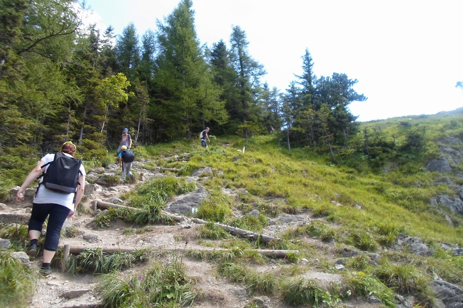
NOSAL is not vey high (1206 mnpm, above sea level -ASL),
usually we go there on the first or the last day, or when the weather is not that good as it should be.
Unfortunatelly, some people think that it is a walking-route so they go like for a stroll in not very comfortable shoes.
Not a good decision.
Our opinions will then be dependent on from which side we start.
The route starts
1. from known point in ZAKOPANE - that is KUŹNICE (the district of the town),
or
2. from the bus stop MUROWANICA.
From the 1st side I think it is much easier, cause hiking up from side of MUROWANICA may be a little harder.
OK, do not worry it is still not the high part of TATRY (TATRA MOUNTAINS).
When you find yourself on the side of KUŻNICE it is possible to make the trip longer and to go through NOSALOWA PRZEŁĘCZ (small mountain pass) further to DOLINA OLCZYSKA, very small but also nice valley.
About OLCZYSKA I will continue next time....
Have a good time watching pictures, especially that one with just-married-couple probably on the wedding session wit a photographer.
I have almost forgotten: from NOSAL there is a beautiful panorama of the mountains including our famous KASPROWY WIERCH.
A film
http://www.youtube.com/watch?v=vDNxRgiS22E
some links
http://natatry.pl/tatry-wysokie/regle-tatr-wysokich/na-nosal-z-kuznic
http://pl.wikipedia.org/wiki/Nosal_(Tatry)
NOSAL, TO KOLEJNE MIEJSCE GDZIE czasem można spotkać turystów w klapkach i sandałach. Jednak nie polecam bo zwłaszcza wejście od strony przystanku MUROWANICA jest momentami ostre, mimo, że przecież nie jest to wysoka górka.
Z drugiej strony szlaku można odbić na NOSALOWĄ PRZEŁĘCZ i udać się dalej do DOLINY OLCZYSKIEJ, ale o tym następnym razem.
Z NOSALA, jak wiadomo, piękne widoki...
Trafiła się nawet sesja ślubna.
od MUROWANICY, FROM THE SIDE OF MUROWANICA
AND HOW IT LOOKS IN WINTER ORAZ ZIMA NA NOSALU
http://bi.gazeta.pl/im/f3/0a/cd/z13437683Q,Zakopane---Nieczynny-wyciag-krzeselkowy-na-szczyt-.jpg
TODAY shortly.
When we plan to go to the mountains it is absolutely obligatory to check the weather.
This year it changes so quickly.
To feel safe before going for a longer trip or to higher parts of mountains the best thing we can do is to trace cameras live situated there.
And watch local wather forecasts, not those shown in news.
So I place now a link to live cameras.Enjoy
http://tatromaniak.pl/aktualnosci/c/robi-sie-pogoda-wieczor-z-kamerkami-na-zywo
http://kamery.topr.pl/kamery
Nie trzeba chyba mówić, kto był w górach to wie, że pogoda lubi się tam zmieniać szybko.
W tym roku chyba szczególnie.
Aby czuć się bezpiecznie, przed wyjściem w dłuższą podróż lub w wyższe partie górpo prostu musimy zainteresować się pogodą, najlepiej informacją TOPR.
Warto śledzić kamery internetowe.Powyżej linki.Miłego wieczoru i dnia i nocy.
Przysłop Miętusi, za plecami KOMINIARSKI WIERCH
PRZYSŁOP MIĘTUSI (SMALL MOUNTAIN PASS),
AND BEHIND ME A VIEW OF KOMINIARSKI WIERCH,
the mountain which we cannot visit - the route is closed there for unique species of eagles which live there.
KOMINIARSKI WIERCH
I would like to share my other pictures from the biggest and longest valley in TATRY mountains DOLINA CHOCHOŁOWSKA.
Because I have mentioned it before I give the link to the previous description, so they could be close "attached".
http://ultrasogood.blogspot.com/2014/08/dolina-chochoowska-tatry.html
Enjoy looking at the valley, at the end of it there is a mountain hostel (shelter) (on the picture me at the entrance) , which is not bad as comparing with other ones in the mountains.
During season you may eat there some delicious food like Polish pierogi (dumplings) filled with berries or pancaces with berries, yammi !!!
From that place you may also go further to see mountains GRZEŚ, RAKOŃ and WOŁOWIEC or as I was writing 2 days ago, to STAROBOCIAŃSKI WIERCH.
http://pl.wikipedia.org/wiki/Grze%C5%9B
http://forum.nikoniarze.pl/showthread.php?t=240241
Dziś ponownie Dolina Chochołowska, najdłuższa z wszystkich w Tatrach.
Na końcu bardzo miłe schronisko, w którym można zjeść coś bardzo pysznego z jagodami lub też z tamtych okolic wyruszyć dalej na
GRZESIA, WOŁOWCA
lub nawet na STAROBOCIAŃSKI WIERCH,
z którego po wielogodzinnej trasie można dojść do Hali Ornak w Dolinie Kościeliskiej.
DOLINA KOŚCIELISKA, some people say it is the most beautiful in our TATRY, some prefer CHOCHOŁOWSKA, by the way there is a route between 2 of them.
It has about 9 km and from there you may go to see magnificent caves that are open for tourists (JASKINIA MROZNA, cave) a film below.
http://www.youtube.com/watch?v=589BXLJy6NQ
Also a known WĄWÓZ KRAKÓW (GORGE KRAKOW).
http://tatromaniak.pl/aktualnosci/c/wawoz-krakow
It is not a secret that DOLINA KOŚCIELISKA is the most famous valley in TATRY.
In summer or during long weekends crowds are visiting it, it quite easy,
when me mean hiking, rather it is walking so families with children like it, as well.
Links abot the valley and my numerous pictures comparing KOSCIELISKA in summer and in winter at the beginning of March 2014.
http://pl.wikipedia.org/wiki/Dolina_Ko%C5%9Bcieliska
crowds in Kościeliska - typical during seson /// tłumy w Kościeliskiej
http://www.tatry.gory24.pl/foto/menu/dolina_koscieliska_zdjecie_glowne.jpg
https://blogger.googleusercontent.com/img/b/R29vZ2xl/AVvXsEgZ9L5rhLxzM809dU7tHpHDb2dPZinm0H-yr4I_Svub1EzzPYTdHtXkPzL66WhLYi_E1pdKxg-tU-2bKS-n8bJUZMbKeRtO9WcZ4-48LSpLz7uhPJZLuEvkq-t5pFyRwjbKB_vS9QwLZ5E/s1600/AG-1.jpg
http://www.tripadvisor.co.uk/Guide-g1087270-i2039-Koscielisko_Lesser_Poland_Province_Southern_Poland.html
http://tatromaniak.pl/szlaki/rejon-doliny-koscieliskiej/dolina-koscieliska
Nic dodać nic ująć, to najsłynniejsza nasza dolina, razem z Chochołowską, zresztą są połączone szlakami.
Ma około 9 km długości, można od strony doliny pójść zwiedzać znane jaskinie np. Mroźną lub Wąwóz Kraków.
Powyżej ciekawe linki polskie i angielskie, film, a potem zdjęcia do porównania KOŚCIELISKA W ZIMIE I W LECIE.Miłego dnia i nocy.
Sorry again my summer pictures are mainly with me.
i zima AND WINTER
MY MISTY MOUNTAINS
STAROBOCIAŃSKI WIERCH.
This is the name of the mountain in TATRY, I havn't been there yet, but really I would like to be. The route is quite long, however not that hard as in High Tatry.
Tatry are divided into eastern - (HIGH TATRY) and western part, the line is crossing PRZEŁĘCZ LILIOWE (mountain pass).
http://portaltatrzanski.com/images/przewodnik/foto/pl032-przelecz-liliowe/pl032%20-%20przecz%20liliowe%202.jpg
Below some links
1. about Starobociański Wierch,
2. the route
3. and a very nice page I have found about juorneys not only to Tatry, but to different places in Poland at the seaside, mountains, lakes and others-it is in Polish, but pictures are very nice, there are also maps etc.
1.
http://pl.wikipedia.org/wiki/Starorobociański_Wierch
http://panoramy.zbooy.pl/360/pan/starorobocianski-wierch-grzbiet/e
http://www.youtube.com/watch?v=SEEKweyRVP8
http://www.youtube.com/watch?v=gxrbZFvifqQ
2.
3.
http://www.rodzinna-turystyka.pl/ciekawe-miejsca/natura/natura-przyroda-foto-spis.html
Mój ciągle niezdobyty, nie mogłam tam na razie pójść.
STAROBOCIAŃSKI WIERCH nie jest w Tatrach Wysokich, ale w Zachodnich, toteż niby nie taki trudny do zdobycia. Problemem jest czas. A zatem musi też być i pewność dobrej pogody.
Nie mam stamtąd zdjęć, dlatego chociaż kawałek Doliny Kościeliskiej, z której można rozpocząć trasę, można też z Chochołowskiej. Niestety, w tamtym czasie produkowałam głownie własne zdjęcia, sorry.
Spod schroniska n Hali Ornak rozpoczyna się prawdziwe wspinanie w kierunku Siwej Przełęczy, góry Ornak i Starobociańskiego.
Szlaki ////Routs
http://www.tatry.info.pl/zachodnie/koscieliska/szlaki.php
I do not have pictures from that place, but here are some from DOLINA KOŚCIELISKA (Valley) from which the route may start, you may also start from DOLINA CHOCHOŁOWSKA (Valley).
Sorry, that the majority of pictures are with me, but in that time I was making mainly my own ones, what a shame. There is shown a mountain shelter at Ornak mountain pasture, from this place the real hiking up starts.
Today it is even colder than I expected, like in Scandinavia, about 20 centigrades and rather rainy and windy.
For a moment I wished to see how our resorts at the seaside look like on such a day, when we feel autumn, however we do not want to feel it.
I have found a page on the internet with access to several live streaming cameras (we call it on-line cameras).
Views are not that sunny as it were a couple of days ago, but looking at the sea is always pleasant.
http://www.moje-morze.pl/livecam.html
And I add streaming from USTRONIE MORSKIE, it was somewhere before, but to put it in one place together.
http://www.ustronie-morskie.pl/index.php?akcja=art_kamery
Pictures for today-randomly selected suiting the weather.
Dziś jest nawet zimniej niż wczoraj, niecałe 20 stopni, popaduje i wieje.
Na chwilę chciałam zobaczyć jak wyglądają dziś nasze kurorty nadmorskie i znalazłam stronę z dostępami on-line, dodałam też podawane już wcześniej Ustronie Morskie.
Widok morza nie jest już skąpany w słońcu, ale zawsze miło na nie popatrzeć. Fotki dobrane do pogody.
KOŁOBRZEG
NIECHORZE
AND ŚWINOUJŚCIE
They are really beautiful, immaculate, perfect or whatever you call it. SUNSETS AT THE SEASIDE.
Luckily we had a quite warm August day, from tomorrow the temperature falls down to more or less 25 Celsius degrees.
As it is said in "Game of Thrones" ,winter is coming, slowly but it is true.
So we should catch rays of sun as much as we can.
From dawn to sunset.
Zachody słońca są niepowtarzalnie przepiękne, zwłaszcza w lecie, a najbardziej to już te nad morzem.
Teraz, kiedy zaczynamy już czuć zbliżającą się zmianę pór roku trzeba łapać każdy promień słońca.
Kołobrzeg
I can feel autumn coming in my bones, mornings are colder, no, no I do not want to! How to keep good memories in mind for the rest of the time...
Czuję po kościach, że zbliża się jesień, nie chcę, nie, nie. Ale ranki coraz zimniejsze. Jak zatrzymać dobre myśli i wspomnienia na resztę dni, do następnego lata lub chociaż wiosny.
I WAS HAPPY THERE (Małołączniak, Czerwone Wierchy) TAM BYŁAM SZCZĘŚLIWA
AND THERE (Kopa Kondracka) I TAM TEŻ
Have a good night, and the day.
To make the topic of BUTOROWY-PAJĄKÓWKA-GUBAŁÓWKA complete, as I was promising before, today the most famous, widely known place GUBAŁÓWKA, not very high (1126m but on some older postcards it is 1123m ) mountain, but in Poland everybody knows it and even very old ladies or small children really may visit it for this simple reson that there is a CABLE RAILWAY.
LINK TO ON-LINE CAMERAS
http://www.pkl.pl/gubalowka/Kamery
AND LINK TO TICKET PRICES FOR THE CABLE
http://www.ezakopane.pl/atrakcje/gubalowka/cennik.html
I was there many times also on foot means HIKING UP OR DOWN, as I mentioned yesterday it is possible to walk along the whole route from BUTOROWY WIERCH (it starts in the nearby village of KOŚCIELISKO), but when you are in ZAKOPANE, it is very easy to reach the top using the cable railway or walk. The trip is not very long and hard depending on what kind of person you are, it may take 30 minutes or 1 hour. If it is hot it becomes more difficult or if it is wet. In winter rather slippery and in that time you see that there are some steep moments. Generally, you walk in the forest or just on the grass. Short and nice walk.
WHAT WE SHOULD KNOW - there is a really beautiful panorama of TATRY from the top of that small mountain.
http://pl.wikipedia.org/wiki/Gubałówka
http://en.wikipedia.org/wiki/Guba%C5%82%C3%B3wka
http://en.wikipedia.org/wiki/Guba%C5%82%C3%B3wka_Hill_Funicular
No cóż. Każdy w Polsce wie, co to jest GUBAŁÓWKA. Dla leniuszków albo starszych osób czy dzieci oczywiście łatwy wjazd kolejeczką-linki powyżej, kamery, ceny biletów etc. Zachęcam do zdobycia jej osobiście, podróż może być momentami dająca w kość, ale to są TATRY, generalnie to pikuś, w porównaniu innymi szlakami. Idziemy przez las lub polanką, gdy żar leje się z nieba to może być trochę męcząca trasa. W zimie raczej dość ślisko. Można też-jak wspominałam wczoraj przejść cały szlak spacerowy od Kościeliska, szlak papieski, kawałkiem asfaltówki, potem szczytem BUTOROWYM, Pająkówką do Gubałówki, a potem zjechać albo zejść.
Nie muszę chyba dodawać, że z Gubałówki rozciąga się przepiękna panorama TATR.
Życzę milej zabawy, na zdjęciach trasa z Butorowego na Gubałówkę, szczytem, tablica ze szczytu, widok z Gubałówki oraz trasa w dół, w tle dźwig do bungee, oraz kule wodne dla dzieciaków (mały zorbing)!!!
BETWEEN BUTOROWY AND GUBAŁÓWKA ON THE TOP -ME
THIS PANORAMA WITH DESCRIPTION AND NAMES OF THE MOUNTAINS IS LOCATED ON THE TOP OF GUBAŁÓWKA
THE VIEW FROM GUBAŁÓWKA (could be better- I mean my picture)
GOING DOWN FROM GUBAŁÓWKA ON FOOT
HAPPY ME GOING DOWN FROM GUBAŁÓWKA WEARING LOCAL HEADSCARF
JUST ALMOST AT THE FINISH OF THIS TRIP, by the way from this crane people may try bungee-jumping, however this year this place is under reconstruction, this picture was taken last year
If you are curious what those plastic balls are, nothing in common with hiking, this is for crazy children like my son, also at the seaside they are very popular, children come into this ball and "walk" on water, it is like zorbing
SORRY THIS PICTURE IS NOT VERY CLEAR, I could not find a betetr one, this is the entrance to the cable railway station.
HAVE A GOOD TIME.